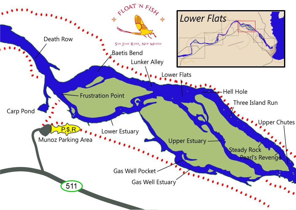
Parking for the Lower Flats Area is just a short distance south from Frustration Point and Baetis Bend and about 2.9 miles up the road on highway 173 and then east on highway 511 from Float 'N Fish to the Munoz parking area. This Navajo Lake State Park parking area supports parking and a pay station but no drinking water. Trails from the parking lot go North to the river near Frustration Point to access the famed Baetis Bend area or proceed upstream for access to the estuaries south of the main channel. The Lower Flats is on the North side of this area and can be accessed from the South side of the river by hiking upstream from Frustration Point past Baetis Bend or through the Lower Estuary or Gas Well Pocket. Be aware that there are many swampy areas on the south side of the river between the river and Hwy 511 which make for very difficult hiking, so it is wise to stay on the trails.
The Lower Flats may also be accessed from the North side of the river by hiking upstream on the path from the Bureau of Land Management (BLM) parking lot at Simon Canyon, or, with a longer walk from Cottonwood Campground.
This area of the river supports large populations of fish including both Rainbows and wild Browns. The main channel on the north side has deep, powerful runs with cover for large fish. Baetis become more prevalent in this area as the water warms and the Lower Flats and especially Baetis Bend are popular with dry fly fishermen. Most of the Lower Flats is wadeable except during runoff providing wading access to a large area with bottom structure, current seams and a good fish population. Lunker Alley is named appropriately - this is a deep, powerful run with current seams/eddies on both sides of the river which holds some very large, powerful fish. Baetis Bend is a popular area with relatively slow water with a smooth surface suitable for both slow Nymphing and dry flies. This area supports a good mayfly population providing good Nymphing and dry fly fishing.
Below Baetis Bend the main channel merges with the estuaries from the south side of the river forming Frustration Point, an area with deep water and large fish. This water then continues downstream forming Death Row, an area of slow, deep water with large fish. Death Row was named by Guides due to the difficulty of rowing downstream in the slow water against the prevailing springtime winds from the southwest. You will need a drift boat or floatation device to successfully cast to the large fish in this area.